The Stratovolcano

About Mount Apo Geopark

Exploring the harmony between international geological significance, pristine ecosystems, and sacred ancestral heritage.

Geopark profile

Geopark at a Glance

A nationally significant protected landscape spanning two administrative regions in south-central Mindanao.

Highest Elevation
2,954 m
Total Area
64,053 ha
Protected Area
54,975 ha
Buffer Zone
9,078 ha
Geographic Coverage
Regions XI & XII

Geological and territorial profile

A mountain shaped by fire and time

Mount Apo’s volcanic landforms, high-elevation ecosystems, and communities form one continuous heritage landscape.

01

Geological Profile & Scope

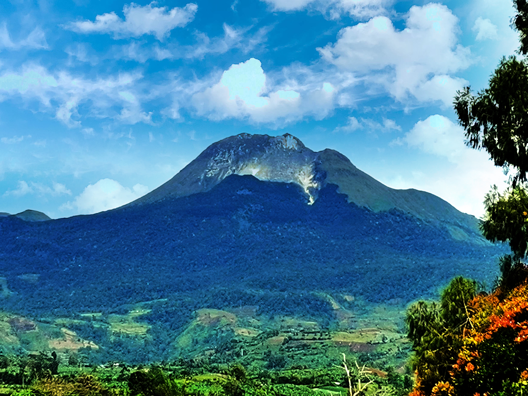
Mount Apo is a potentially active stratovolcano rising 2,954 meters above sea level, making it the highest peak in the Philippines. It covers 64,053 hectares: 54,975 hectares of protected area and a 9,078-hectare buffer zone.

It was formally established as a Natural Park on February 3, 2004, and declared a local geopark on July 27, 2022, thereby functioning as a de facto geopark.

02

Territorial Reach

Situated in south-central Mindanao, the aspiring UNESCO Global Geopark spans Regions XI and XII. It covers parts of Cotabato (Magpet, Makilala, Kidapawan City), Davao del Sur (Bansalan, Sta. Cruz, Digos City), and Davao City.

The rugged Apo–Talomo Mountain Range is defined by steep slopes, ridges, gorges, and towering peaks shaped by volcanic and tectonic processes.

Mount Apo summit · 6.9875° N, 125.2708° E

Culture and biodiversity

One mountain, a living heritage

The identity of Mount Apo is inseparable from its ancestral communities and the exceptional life sustained across its slopes.

Mount Apo, known in ancestral tradition as Apo Sandawa

Sacred Culture & Ancestral Domain

Apo Sandawa

The geopark takes its name from “Apo Sandawa,” a revered ancestral figure deeply honored by the Indigenous Peoples of the mountain. It is home to the Bagobo Tagabawa, Bagobo Klata, and Ubu Monuvu, whose ancestral domains share boundaries with Mount Apo.

For generations, these communities have regarded the mountain as sacred and sustained tangible and intangible heritage through stories, practices, and artifacts.

Ecological Framework

A sanctuary of exceptional life

Within the Mindanao Biogeographic Zone, variations in altitude, slope, and microclimate create habitats for 378 vertebrate species.

These include the critically endangered Philippine Eagle (Pithecophaga jefferyi), Mindanao endemics such as the Apo Sunbird and Apo Myna, and high-altitude specialists including the Mindanao Fanged Frog.

Philippine Eagle in the Mount Apo landscape

Global framework

Understanding UNESCO Global Geoparks

UNESCO Global Geopark

What is a UNESCO Global Geopark?

UNESCO Global Geoparks (UGGp) are single, unified geographical areas where sites and landscapes of international geological significance are managed through a holistic framework.

Learn more at UNESCO
  1. 01Protection

    Safeguard geological, natural, and cultural heritage.

  2. 02Education

    Build understanding of landscapes and the processes that shape them.

  3. 03Sustainable Development

    Support responsible local opportunity and long-term community benefit.

Community-driven by design. The bottom-up approach actively involves local people in safeguarding and benefiting from their geological heritage.

Legal Foundation

Republic Act
No. 9237

The Mount Apo Geopark shares the legally established boundary of the Mount Apo Natural Park, as outlined in Republic Act No. 9237.

De Facto Geopark Structure

Mount Apo Natural Park provides the territorial and institutional foundation of the geopark and is recognized as natural heritage through national, international, and local designations.

Institutional Oversight

Governance & Management

The Mount Apo Geopark Management Unit operates under the direct supervision of the Protected Area Superintendent (PASu), aligning Geopark objectives with protected-area policies and conservation priorities.

National Level Management & Administration

Secretary

Department of Environment & Natural Resources (DENR)

Official structure

Geopark Organizational Structure

Mount Apo Natural Park and Geopark management and administrative relationships.

Site Level Management

Regional Executive Director (RED)

DENR Regions XI & XII

Protected Area Management Board (PAMB)

Sub-PAMB of Cotabato;
Sub-PAMB of Davao del Sur;
Sub-PAMB of Davao City;
Geopark Management Committee

Head of the Indigenous Political Structure (IPS)

Ancestral Domains of Bagobo-Tagabawa, Bagobo-Klata, and Ubu Monuvu

Provincial Environment & Natural Resources Officers

DENR Cotabato & Davao del Sur

Protected Area Superintendent / Geopark Manager

Protected Area Management Office of Cotabato & Davao del Sur;
Geopark Management Unit’s Office of Cotabato & Davao del Sur

Ancestral Domain Management Office

Bagobo-Tagabawa, Bagobo-Klata, and Ubu Monuvu

Horizontal Line — Equal authority / Functional collaborationVertical Line — Direct authority or supervision

Official channels

Contact & Transparency

Connect with the official administrative offices of Mount Apo Geopark.

Official Records Email

records.manpdenr11@gmail.com

Office of the PASu Email

manpdenr11@gmail.com

Official Facebook Page

Mount Apo Geopark

Contact Number

0950-517-1846